
Cloud Peak Glacier topographic map
Interactive map
Click on the map to display elevation.
About this map
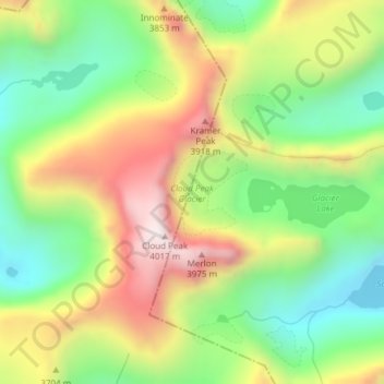
Name: Cloud Peak Glacier topographic map, elevation, terrain.
Location: Cloud Peak Glacier, Johnson County, Wyoming, United States (44.38221 -107.17311 44.38824 -107.16584)
Average elevation: 3,603 m
Minimum elevation: 3,287 m
Maximum elevation: 4,016 m
Other topographic maps
Click on a map to view its topography, its elevation and its terrain.
Buffalo
United States > Wyoming > Johnson County
Buffalo, Johnson County, Wyoming, 82834, United States
Average elevation: 1,437 m
Buffalo
United States > Wyoming > Johnson County
Buffalo, Johnson County, Wyoming, 82834, United States
Average elevation: 1,442 m