
Make a donation
Gear up for your next adventure:
As an Amazon Associate, this site earns from qualifying purchases at no extra cost to you.
Nijeveen topographic map
Click on the map to display elevation.
Make a donation
Gear up for your next adventure:
As an Amazon Associate, this site earns from qualifying purchases at no extra cost to you.
Nijeveen
Nijeveen is een dorp dat van oudsher veel evenementen organiseert. Zo is er elk jaar een dorpsfeest. Dat is het hoogtepunt van het jaar voor vele Nijeveners. Hieronder een aantal evenementen in Nijeveen.
Make a donation
Gear up for your next adventure:
As an Amazon Associate, this site earns from qualifying purchases at no extra cost to you.
About this map
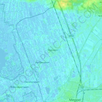
Name: Nijeveen topographic map, elevation, terrain.
Location: Nijeveen, Meppel, Drenthe, Nederland (52.69213 6.12006 52.77305 6.20192)
Average elevation: 1 m
Minimum elevation: -4 m
Maximum elevation: 16 m
Make a donation
Gear up for your next adventure:
As an Amazon Associate, this site earns from qualifying purchases at no extra cost to you.
Other topographic maps
Click on a map to view its topography, its elevation and its terrain.