
Fleury-les-Aubrais topographic map
Interactive map
Click on the map to display elevation.
About this map
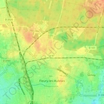
Name: Fleury-les-Aubrais topographic map, elevation, terrain.
Average elevation: 124 m
Minimum elevation: 103 m
Maximum elevation: 140 m
Le territoire communal est relativement plat puisque la dénivelée maximale est de 24 mètres. L'altitude du territoire varie en effet de 109 mètres à 133 mètres.
Other topographic maps
Click on a map to view its topography, its elevation and its terrain.
Sainte-Catherine
France > Centre-Val de Loire > Loiret > Pannes
Sainte-Catherine, Pannes, Montargis, Loiret, Centre-Val de Loire, France métropolitaine, 45700, France
Average elevation: 91 m
Cepoy
France > Centre-Val de Loire > Loiret
Cepoy, Montargis, Loiret, Centre-Val de Loire, France métropolitaine, 45120, France
Average elevation: 94 m
Montargis
France > Centre-Val de Loire > Loiret
Montargis, Loiret, Centre-Val de Loire, France métropolitaine, 45200, France
Average elevation: 92 m
Corquilleroy
France > Centre-Val de Loire > Loiret
Corquilleroy, Montargis, Loiret, Centre-Val de Loire, France métropolitaine, 45120, France
Average elevation: 93 m
Saran
France > Centre-Val de Loire > Loiret
Saran, Orléans, Loiret, Centre-Val de Loire, France métropolitaine, 45770, France
Average elevation: 122 m
Conflans-sur-Loing
France > Centre-Val de Loire > Loiret
Conflans-sur-Loing, Montargis, Loiret, Centre-Val de Loire, France métropolitaine, 45700, France
Average elevation: 108 m
Meung-sur-Loire
France > Centre-Val de Loire > Loiret
Meung-sur-Loire, Orléans, Loiret, Centre-Val de Loire, France métropolitaine, 45130, France
Average elevation: 99 m