
Impruneta topographic map
Interactive map
Click on the map to display elevation.
About this map
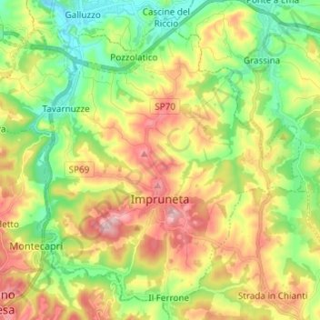
Name: Impruneta topographic map, elevation, terrain.
Average elevation: 173 m
Minimum elevation: 53 m
Maximum elevation: 340 m
Other topographic maps
Click on a map to view its topography, its elevation and its terrain.
Florence
Italy > Tuscany > Metropolitan City of Florence > Florence
Florence, Metropolitan City of Florence, Tuscany, 50100, Italy
Average elevation: 238 m
Londa
Italy > Tuscany > Metropolitan City of Florence
Londa, Metropolitan City of Florence, Tuscany, Italy
Average elevation: 574 m
Rufina
Italy > Tuscany > Metropolitan City of Florence
Rufina, Metropolitan City of Florence, Tuscany, Italy
Average elevation: 396 m
Due Strade
Italy > Tuscany > Metropolitan City of Florence > Florence
Due Strade, Quartiere 3, Florence, Metropolitan City of Florence, Tuscany, 50124, Italy
Average elevation: 93 m
Sesto Fiorentino
Italy > Tuscany > Metropolitan City of Florence
Sesto Fiorentino, Metropolitan City of Florence, Tuscany, Italy
Average elevation: 187 m
Morrocco
Italy > Tuscany > Metropolitan City of Florence > Sambuca
Morrocco, Sambuca, Barberino Tavarnelle, Metropolitan City of Florence, Tuscany, 50028, Italy
Average elevation: 288 m
Pontassieve
Italy > Tuscany > Metropolitan City of Florence > Pontassieve
Pontassieve, Metropolitan City of Florence, Tuscany, 50065, Italy
Average elevation: 364 m