Geolocate

Lincoln topographic map

Interactive map

Click on the map to display elevation.

About this map

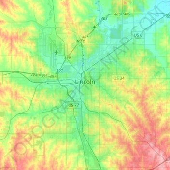
Name: Lincoln topographic map, elevation, terrain.

Location: Lincoln, Lancaster County, Nebraska, United States (40.69377 -96.80415 40.91500 -96.56752)

Average elevation: 379 m

Minimum elevation: 340 m

Maximum elevation: 447 m

Other topographic maps

Click on a map to view its topography, its elevation and its terrain.

Lincoln

United States > Nebraska > Lancaster County > Lincoln

Lincoln, Lancaster County, Nebraska, 68508, United States

Average elevation: 387 m

Landon's

United States > Nebraska > Lancaster County > Lincoln

Landon's, Lincoln, Lancaster County, Nebraska, United States

Average elevation: 360 m

Lancaster County

United States > Nebraska > Lancaster County

Lancaster County, Nebraska, United States

Average elevation: 401 m