
Xã Tân An topographic map
Interactive map
Click on the map to display elevation.
About this map
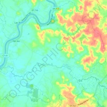
Name: Xã Tân An topographic map, elevation, terrain.
Location: Xã Tân An, Vĩnh Cửu District, Đồng Nai Province, Vietnam (10.98989 106.90620 11.07559 106.99474)
Average elevation: 23 m
Minimum elevation: 0 m
Maximum elevation: 74 m
Other topographic maps
Click on a map to view its topography, its elevation and its terrain.
Xã Thiện Tân
Vietnam > Dong Nai province > Vĩnh Cửu District
Xã Thiện Tân, Vĩnh Cửu District, Đồng Nai Province, 76913, Vietnam
Average elevation: 20 m
Xã Mã Đà
Vietnam > Dong Nai province > Vĩnh Cửu District
Xã Mã Đà, Vĩnh Cửu District, Đồng Nai Province, Vietnam
Average elevation: 65 m
Xã Bình Lợi
Vietnam > Dong Nai province > Vĩnh Cửu District
Xã Bình Lợi, Vĩnh Cửu District, Đồng Nai Province, Vietnam
Average elevation: 9 m
Xã Trị An
Vietnam > Dong Nai province > Vĩnh Cửu District
Xã Trị An, Vĩnh Cửu District, Đồng Nai Province, Vietnam
Average elevation: 28 m