
Prentiss topographic map
Interactive map
Click on the map to display elevation.
About this map
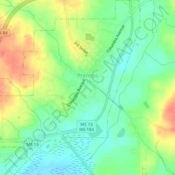
Name: Prentiss topographic map, elevation, terrain.
Location: Prentiss, Jefferson Davis County, Mississippi, United States (31.58142 -89.88667 31.61149 -89.85649)
Average elevation: 107 m
Minimum elevation: 85 m
Maximum elevation: 139 m
Other topographic maps
Click on a map to view its topography, its elevation and its terrain.
Hathorn
United States > Mississippi > Jefferson Davis County > Hathorn
Hathorn, Jefferson Davis County, Mississippi, United States
Average elevation: 62 m