
Sawtell Peak topographic map
Interactive map
Click on the map to display elevation.
About this map
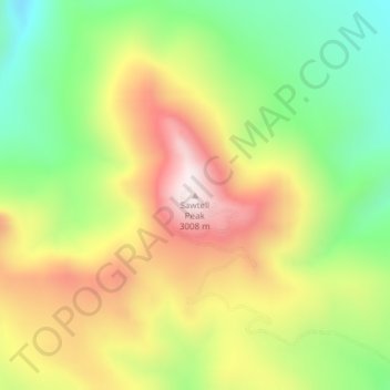
Name: Sawtell Peak topographic map, elevation, terrain.
Location: Sawtell Peak, Fremont County, Idaho, United States (44.56154 -111.44445 44.56164 -111.44435)
Average elevation: 2,661 m
Minimum elevation: 2,352 m
Maximum elevation: 3,016 m
Other topographic maps
Click on a map to view its topography, its elevation and its terrain.
Box Canyon
United States > Idaho > Fremont County
Box Canyon, Fremont County, Idaho, United States
Average elevation: 1,891 m
Island Park
United States > Idaho > Fremont County
Island Park, Fremont County, Idaho, United States
Average elevation: 2,113 m