
Pstrąże topographic map
Interactive map
Click on the map to display elevation.
About this map
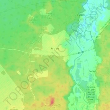
Name: Pstrąże topographic map, elevation, terrain.
Average elevation: 151 m
Minimum elevation: 133 m
Maximum elevation: 176 m
Other topographic maps
Click on a map to view its topography, its elevation and its terrain.
Świętoszów
Poland > Lower Silesian Voivodeship > Bolesławiec County
Świętoszów, gmina Osiecznica, Bolesławiec County, Lower Silesian Voivodeship, 59-726, Poland
Average elevation: 143 m
Bolesławiec
Poland > Lower Silesian Voivodeship > Bolesławiec County > Bolesławiec
Bolesławiec, Bolesławiec County, Lower Silesian Voivodeship, Poland
Average elevation: 201 m