
Bashkia Durrës topographic map
Interactive map
Click on the map to display elevation.
About this map
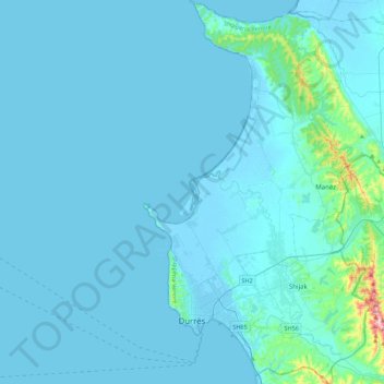
Name: Bashkia Durrës topographic map, elevation, terrain.
Location: Bashkia Durrës, Durrës County, Northern Albania, Albania (41.25890 19.39150 41.58799 19.62494)
Average elevation: 23 m
Minimum elevation: -5 m
Maximum elevation: 460 m
Other topographic maps
Click on a map to view its topography, its elevation and its terrain.
Durrës
Albania > Northern Albania > Durrës County > Bashkia Durrës
Durrës, Bashkia Durrës, Durrës County, Northern Albania, 2001, Albania
Average elevation: 7 m
Nikël
Albania > Northern Albania > Durrës County > Kruje
Nikël, Kruje, Durrës County, Northern Albania, 1504, Albania
Average elevation: 107 m