
Make a donation
Gear up for your next adventure:
As an Amazon Associate, this site earns from qualifying purchases at no extra cost to you.
La Rinconada topographic map
Click on the map to display elevation.
Make a donation
Gear up for your next adventure:
As an Amazon Associate, this site earns from qualifying purchases at no extra cost to you.
La Rinconada
High in the Andes, La Rinconada has an alpine tundra climate (ET, according to the Köppen climate classification), with no month having mean temperatures even close to the 10 °C (50 °F) threshold that would permit tree growth and a subtropical highland classification for the city. Far above the tree line, La Rinconada is unique in its high elevation and population, with the highest city of comparable population (Nagqu) being over 500 m (1,600 ft; 0.31 mi) closer to sea level.
Make a donation
Gear up for your next adventure:
As an Amazon Associate, this site earns from qualifying purchases at no extra cost to you.
About this map
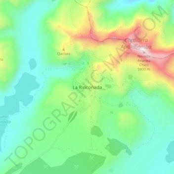
Name: La Rinconada topographic map, elevation, terrain.
Average elevation: 4,923 m
Minimum elevation: 4,550 m
Maximum elevation: 5,834 m
Make a donation
Gear up for your next adventure:
As an Amazon Associate, this site earns from qualifying purchases at no extra cost to you.
Other topographic maps
Click on a map to view its topography, its elevation and its terrain.
Lake Titicaca
Lake Titicaca has a surface elevation of 3,812 m (12,507 ft). The "highest lake" claim is generally considered to refer to commercial craft. Numerous smaller bodies of water (that are not considered lakes) around the world are at higher elevations. For many years, the largest vessel afloat on the lake was the…
Average elevation: 3,870 m
Make a donation
Gear up for your next adventure:
As an Amazon Associate, this site earns from qualifying purchases at no extra cost to you.
Province of Chucuito
One of the highest elevations of the province is Chuqi Patilla at approximately 5,200 m (17,100 ft). Other mountains are listed below.
Average elevation: 4,051 m
Make a donation
Gear up for your next adventure:
As an Amazon Associate, this site earns from qualifying purchases at no extra cost to you.