Geolocate

Del Rio topographic map

Click on the map to display elevation.

About this map

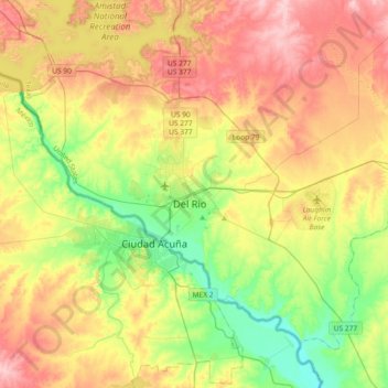
Name: Del Rio topographic map, elevation, terrain.

Location: Del Rio, Val Verde County, Texas, 78841, United States (29.20554 -101.05470 29.52554 -100.73470)

Average elevation: 326 m

Minimum elevation: 253 m

Maximum elevation: 412 m

Gear up for your next adventure:

🔦Outdoor Torches - Reliable torches for night navigation
📚UK Hiking Guidebooks - Detailed route descriptions for the Lake District, Peaks, and Highlands
Insulated Travel Mugs - Keep drinks hot while surveying the landscape from a summit
Lightweight Solo Tents - Backpacking tents designed for wild camping in the UK highlands
👕Merino Base Layers - Natural temperature regulation for cold weather hiking and camping

As an Amazon Associate, this site earns from qualifying purchases at no extra cost to you.