
Thank you for supporting this site ❤️
Make a donation
Make a donation
Gear up for your next adventure:
As an Amazon Associate, this site earns from qualifying purchases at no extra cost to you.
Zimatlán topographic map
Click on the map to display elevation.
Thank you for supporting this site ❤️
Make a donation
Make a donation
Gear up for your next adventure:
As an Amazon Associate, this site earns from qualifying purchases at no extra cost to you.
About this map
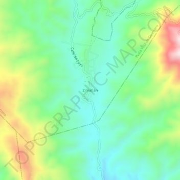
Name: Zimatlán topographic map, elevation, terrain.
Location: Zimatlán, Putla Villa de Guerrero, Oaxaca, México (16.91306 -97.85083 16.95306 -97.81083)
Average elevation: 927 m
Minimum elevation: 754 m
Maximum elevation: 1,287 m
Thank you for supporting this site ❤️
Make a donation
Make a donation
Gear up for your next adventure:
As an Amazon Associate, this site earns from qualifying purchases at no extra cost to you.