
Make a donation
Gear up for your next adventure:
As an Amazon Associate, this site earns from qualifying purchases at no extra cost to you.
Kralendijk topographic map
Click on the map to display elevation.
Make a donation
Gear up for your next adventure:
As an Amazon Associate, this site earns from qualifying purchases at no extra cost to you.
About this map
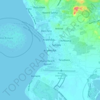
Name: Kralendijk topographic map, elevation, terrain.
Location: Kralendijk, Bonaire, Netherlands, 1234 AB, Netherlands (12.10729 -68.31402 12.18729 -68.23402)
Average elevation: 9 m
Minimum elevation: -2 m
Maximum elevation: 114 m
Make a donation
Gear up for your next adventure:
As an Amazon Associate, this site earns from qualifying purchases at no extra cost to you.
Other topographic maps
Click on a map to view its topography, its elevation and its terrain.
Amsterdam
Amsterdam is located in the Western Netherlands, in the province of North Holland, the capital of which is not Amsterdam, but rather Haarlem. The river Amstel ends in the city centre and connects to a large number of canals that eventually terminate in the IJ. Amsterdam's elevation is about −2 m (−6.6 ft)…
Average elevation: 0 m
Make a donation
Gear up for your next adventure:
As an Amazon Associate, this site earns from qualifying purchases at no extra cost to you.
Eindhoven
The villages and city that make up modern Eindhoven were originally built on sandy elevations between the Dommel, Gender and Tongelreep rivers. Beginning in the 19th century, the basins of the rivers themselves have also been used as housing land, resulting in occasional flooding in the city centre. Partly to…
Average elevation: 20 m
Make a donation
Gear up for your next adventure:
As an Amazon Associate, this site earns from qualifying purchases at no extra cost to you.
Bonaire
While Bonaire has some hills and variations in altitude, Klein Bonaire's surface is quite level and just about two meters above sea level. Because Klein Bonaire is as yet undeveloped, the fringing reef system surrounding Klein Bonaire is pristine.
Average elevation: 1 m
Make a donation
Gear up for your next adventure:
As an Amazon Associate, this site earns from qualifying purchases at no extra cost to you.
Amsterdam
Amsterdam is located in the Western Netherlands, in the province of North Holland, the capital of which is not Amsterdam, but rather Haarlem. The river Amstel ends in the city centre and connects to a large number of canals that eventually terminate in the IJ. Amsterdam's elevation is about −2 m (−6.6 ft)…
Average elevation: 0 m
Make a donation
Gear up for your next adventure:
As an Amazon Associate, this site earns from qualifying purchases at no extra cost to you.
Make a donation
Gear up for your next adventure:
As an Amazon Associate, this site earns from qualifying purchases at no extra cost to you.
Make a donation
Gear up for your next adventure:
As an Amazon Associate, this site earns from qualifying purchases at no extra cost to you.
North Brabant
The historical region of Kempen occupies the southern part of the province of Noord-Brabant and extends south of Eindhoven far into northern Belgium. To the east it reaches as far as the Meuse valley. The surface topography of De Kempen is very uniform. Most of it lies between 5 m (15 ft) and 35 m (115 ft)…
Average elevation: 22 m
Make a donation
Gear up for your next adventure:
As an Amazon Associate, this site earns from qualifying purchases at no extra cost to you.
Make a donation
Gear up for your next adventure:
As an Amazon Associate, this site earns from qualifying purchases at no extra cost to you.
Sliedrecht
Dutch topographic map of the municipality of Sliedrecht, June 2015
Average elevation: 0 m
Make a donation
Gear up for your next adventure:
As an Amazon Associate, this site earns from qualifying purchases at no extra cost to you.
Make a donation
Gear up for your next adventure:
As an Amazon Associate, this site earns from qualifying purchases at no extra cost to you.
Make a donation
Gear up for your next adventure:
As an Amazon Associate, this site earns from qualifying purchases at no extra cost to you.
Make a donation
Gear up for your next adventure:
As an Amazon Associate, this site earns from qualifying purchases at no extra cost to you.
Eindhoven
The villages and city that make up modern Eindhoven were originally built on sandy elevations between the Dommel, Gender and Tongelreep rivers. Beginning in the 19th century, the basins of the rivers themselves have also been used as housing land, resulting in occasional flooding in the city centre. Partly to…
Average elevation: 20 m
Make a donation
Gear up for your next adventure:
As an Amazon Associate, this site earns from qualifying purchases at no extra cost to you.
Landgraaf
Dutch topographic map of the municipality of Landgraaf, June 2015
Average elevation: 126 m
Make a donation
Gear up for your next adventure:
As an Amazon Associate, this site earns from qualifying purchases at no extra cost to you.
Make a donation
Gear up for your next adventure:
As an Amazon Associate, this site earns from qualifying purchases at no extra cost to you.
Make a donation
Gear up for your next adventure:
As an Amazon Associate, this site earns from qualifying purchases at no extra cost to you.
Make a donation
Gear up for your next adventure:
As an Amazon Associate, this site earns from qualifying purchases at no extra cost to you.
North Brabant
The historical region of Kempen occupies the southern part of the province of Noord-Brabant and extends south of Eindhoven far into northern Belgium. To the east it reaches as far as the Meuse valley. The surface topography of De Kempen is very uniform. Most of it lies between 5 m (15 ft) and 35 m (115 ft)…
Average elevation: 22 m
Make a donation
Gear up for your next adventure:
As an Amazon Associate, this site earns from qualifying purchases at no extra cost to you.
Make a donation
Gear up for your next adventure:
As an Amazon Associate, this site earns from qualifying purchases at no extra cost to you.
Make a donation
Gear up for your next adventure:
As an Amazon Associate, this site earns from qualifying purchases at no extra cost to you.
Amsterdam
Amsterdam is located in the Western Netherlands, in the province of North Holland, the capital of which is not Amsterdam, but rather Haarlem. The river Amstel ends in the city centre and connects to a large number of canals that eventually terminate in the IJ. Amsterdam's elevation is about −2 m (−6.6 ft)…
Average elevation: 0 m
Make a donation
Gear up for your next adventure:
As an Amazon Associate, this site earns from qualifying purchases at no extra cost to you.
Reimerswaal
Dutch Topographic map of the municipality of Reimerswaal, June 2015
Average elevation: 0 m
Make a donation
Gear up for your next adventure:
As an Amazon Associate, this site earns from qualifying purchases at no extra cost to you.
Make a donation
Gear up for your next adventure:
As an Amazon Associate, this site earns from qualifying purchases at no extra cost to you.
Make a donation
Gear up for your next adventure:
As an Amazon Associate, this site earns from qualifying purchases at no extra cost to you.
Dronten
Dutch Topographic map of Dronten (town), March 2014.
Average elevation: 0 m
Make a donation
Gear up for your next adventure:
As an Amazon Associate, this site earns from qualifying purchases at no extra cost to you.