
Make a donation
Gear up for your next adventure:
As an Amazon Associate, this site earns from qualifying purchases at no extra cost to you.
Jansanas topographic map
Click on the map to display elevation.
Make a donation
Gear up for your next adventure:
As an Amazon Associate, this site earns from qualifying purchases at no extra cost to you.
About this map
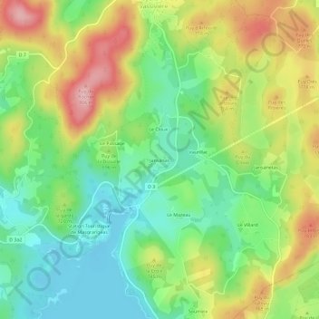
Name: Jansanas topographic map, elevation, terrain.
Average elevation: 714 m
Minimum elevation: 646 m
Maximum elevation: 812 m
Make a donation
Gear up for your next adventure:
As an Amazon Associate, this site earns from qualifying purchases at no extra cost to you.
Other topographic maps
Click on a map to view its topography, its elevation and its terrain.
Lac de Vassivière
France > Nouvelle-Aquitaine > Creuse > Royère-de-Vassivière
Radio Vassivière est une radio locale dont le siège est à Royère de Vassivière. Elle a été créée en 1984 uniquement pour promouvoir le tourisme autour du lac de Vassivière et émet seulement pendant la période estivale de juillet et août. Après une année difficile en 1986 où elle cesse…
Average elevation: 684 m
Barrage de Vassivière
France > Nouvelle-Aquitaine > Creuse > Royère-de-Vassivière
Average elevation: 653 m