
South Tapanuli topographic map
Interactive map
Click on the map to display elevation.
About this map
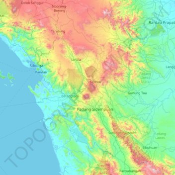
Name: South Tapanuli topographic map, elevation, terrain.
Location: South Tapanuli, North Sumatra, Indonesia (0.97569 98.11806 2.12645 99.57636)
Average elevation: 450 m
Minimum elevation: -1 m
Maximum elevation: 2,267 m
Other topographic maps
Click on a map to view its topography, its elevation and its terrain.
Binanga
Indonesia > North Sumatra > South Tapanuli
Binanga, South Tapanuli, North Sumatra, Sumatra, Indonesia
Average elevation: 1,115 m
Perk Marancar
Indonesia > North Sumatra > South Tapanuli > Perk Marancar
Perk Marancar, South Tapanuli, North Sumatra, Indonesia
Average elevation: 388 m
Liang
Indonesia > North Sumatra > South Tapanuli > Liang
Liang, South Tapanuli, North Sumatra, Indonesia
Average elevation: 870 m