Geolocate

Factory Butte topographic map

Click on the map to display elevation.

About this map

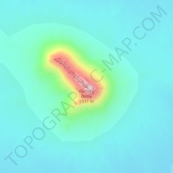
Name: Factory Butte topographic map, elevation, terrain.

Location: Factory Butte, Wayne County, Utah, United States (38.43782 -110.91442 38.43792 -110.91432)

Average elevation: 1,517 m

Minimum elevation: 1,451 m

Maximum elevation: 1,889 m

Other topographic maps

Click on a map to view its topography, its elevation and its terrain.

Teasdale

United States > Utah > Wayne County > Teasdale

Average elevation: 2,197 m

Loa

United States > Utah > Wayne County

Average elevation: 2,158 m

Torrey

United States > Utah > Wayne County

Average elevation: 2,090 m

Hanksville

United States > Utah > Wayne County

Average elevation: 1,330 m

Gear up for your next adventure:

🛌Sleeping Bags - Warm and packable sleeping bags for outdoor nights
🧦Merino Wool Hiking Socks - Moisture-wicking socks to prevent blisters during long mountain walks
🗺️Ordnance Survey Maps - Essential paper maps for hiking across the UK national parks
🥾Women's Waterproof Hiking Boots - High-performance trekking boots designed for all-weather comfort
🎒Multi-day Trekking Packs - Large capacity backpacks for wild camping and long-distance trails

As an Amazon Associate, this site earns from qualifying purchases at no extra cost to you.