
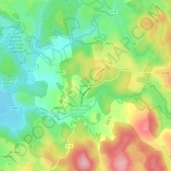
La Ganne topographic map
Interactive map
Click on the map to display elevation.
About this map
Name: La Ganne topographic map, elevation, terrain.
Average elevation: 842 m
Minimum elevation: 774 m
Maximum elevation: 936 m
Other topographic maps
Click on a map to view its topography, its elevation and its terrain.
Le Pont
France > Nouvelle-Aquitaine > Corrèze > Saint-Merd-les-Oussines
Le Pont, Saint-Merd-les-Oussines, Ussel, Corrèze, Nouvelle-Aquitaine, France métropolitaine, 19170, France
Average elevation: 847 m
La Côte
France > Nouvelle-Aquitaine > Corrèze > Saint-Merd-les-Oussines > La Côte
La Côte, Saint-Merd-les-Oussines, Ussel, Corrèze, Nouvelle-Aquitaine, France métropolitaine, 19170, France
Average elevation: 838 m
Fournol
France > Nouvelle-Aquitaine > Corrèze > Saint-Merd-les-Oussines > Fournol
Fournol, Saint-Merd-les-Oussines, Ussel, Corrèze, Nouvelle-Aquitaine, France métropolitaine, 19170, France
Average elevation: 792 m