
Bald Eagle State Park topographic map
Interactive map
Click on the map to display elevation.
Bald Eagle State Park
Foster Joseph Sayers Reservoir is a 1,730-acre (700 ha) reservoir that was built in 1971 by the U.S. Army Corps of Engineers as part of a flood control project on the Susquehanna River basin. The lake was created by damming Bald Eagle Creek. It stretches upstream for 8 miles (12.87 km) and has 23 miles (37.01 km) of shoreline. The park is at an elevation of 958 feet (292 m).[1]
About this map
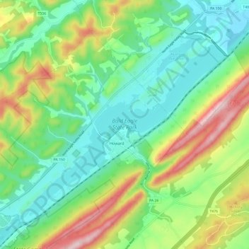
Name: Bald Eagle State Park topographic map, elevation, terrain.
Average elevation: 290 m
Minimum elevation: 174 m
Maximum elevation: 525 m
Other topographic maps
Click on a map to view its topography, its elevation and its terrain.
Dalevue Park
United States > Pennsylvania > Centre County > State College > Dalevue
Average elevation: 331 m