
Make a donation
Gear up for your next adventure:
As an Amazon Associate, this site earns from qualifying purchases at no extra cost to you.
Plateau de Saclay topographic map
Click on the map to display elevation.
Make a donation
Gear up for your next adventure:
As an Amazon Associate, this site earns from qualifying purchases at no extra cost to you.
Plateau de Saclay
Le plateau est situé à une altitude de 150 à 160 m entre la vallée de la Bièvre (de sa source, à Guyancourt jusqu'à Igny, au nord), et les vallées de la Mérantaise et de l'Yvette (de son confluent avec celle-ci jusqu'à Palaiseau au sud); il s'étend au nord-ouest sur la ville nouvelle de Saint-Quentin-en-Yvelines, jusqu'à l'étang de Saint-Quentin.
Make a donation
Gear up for your next adventure:
As an Amazon Associate, this site earns from qualifying purchases at no extra cost to you.
About this map
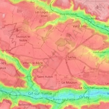
Name: Plateau de Saclay topographic map, elevation, terrain.
Average elevation: 138 m
Minimum elevation: 54 m
Maximum elevation: 182 m
Make a donation
Gear up for your next adventure:
As an Amazon Associate, this site earns from qualifying purchases at no extra cost to you.