Geolocate

Jever topographic map

Click on the map to display elevation.

About this map

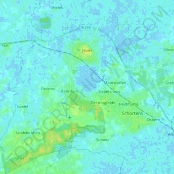
Name: Jever topographic map, elevation, terrain.

Location: Jever, Wangerland, Landkreis Friesland, Lower Saxony, 26441, Germany (53.50094 7.81537 53.60284 7.95296)

Average elevation: 3 m

Minimum elevation: -3 m

Maximum elevation: 13 m

Other topographic maps

Click on a map to view its topography, its elevation and its terrain.

Gear up for your next adventure:

📱Rugged Phone Cases - Heavy-duty protection for smartphones used as secondary GPS tools
🧭GPS Trackers - Tracking devices for safety and navigation
🥤Hydration Bladders - Hands-free hydration systems for backpacks
👟Women's Trail Running Shoes - Agile footwear for fell running and technical trails
🧭Professional Hiking Compasses - High-precision liquid-filled compasses for map reading and orientation

As an Amazon Associate, this site earns from qualifying purchases at no extra cost to you.