
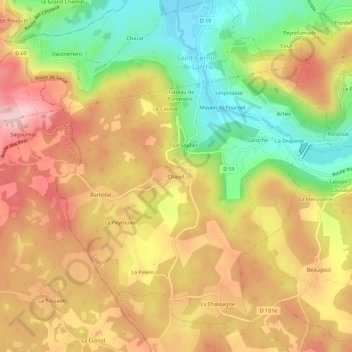
Chaleil topographic map
Interactive map
Click on the map to display elevation.
About this map
Name: Chaleil topographic map, elevation, terrain.
Average elevation: 232 m
Minimum elevation: 98 m
Maximum elevation: 349 m
Other topographic maps
Click on a map to view its topography, its elevation and its terrain.
Moulin de Fournet
France > Nouvelle-Aquitaine > Corrèze > Saint-Cernin-de-Larche > Moulin de Fournet
Moulin de Fournet, Saint-Cernin-de-Larche, Brive-la-Gaillarde, Corrèze, Nouvelle-Aquitaine, France métropolitaine, 19600, France
Average elevation: 200 m
Barbelat
France > Nouvelle-Aquitaine > Corrèze > Saint-Cernin-de-Larche > Barbelat
Barbelat, Saint-Cernin-de-Larche, Brive-la-Gaillarde, Corrèze, Nouvelle-Aquitaine, France métropolitaine, 19600, France
Average elevation: 252 m
Fournet
France > Nouvelle-Aquitaine > Corrèze > Saint-Cernin-de-Larche
Fournet, Saint-Cernin-de-Larche, Brive-la-Gaillarde, Corrèze, Nouvelle-Aquitaine, France métropolitaine, 19600, France
Average elevation: 179 m