
九台区 topographic map
Interactive map
Click on the map to display elevation.
About this map
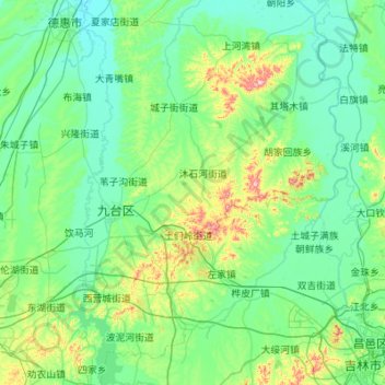
Name: 九台区 topographic map, elevation, terrain.
Location: 九台区, 长春市, 吉林省, 130500, 中国 (43.84681 125.40511 44.52615 126.49877)
Average elevation: 212 m
Minimum elevation: 155 m
Maximum elevation: 571 m
Other topographic maps
Click on a map to view its topography, its elevation and its terrain.
南岭1932 长春水文化生态园
南岭1932 长春水文化生态园, 鸿城街道, 南关区, 长春市, 吉林省, 130000, 中国
Average elevation: 216 m