Geolocate

Pullenvale topographic map

Click on the map to display elevation.

About this map

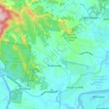
Name: Pullenvale topographic map, elevation, terrain.

Location: Pullenvale, Brisbane City, Queensland, Australia (-27.54140 152.84348 -27.49553 152.92263)

Average elevation: 73 m

Minimum elevation: 2 m

Maximum elevation: 372 m

Other topographic maps

Click on a map to view its topography, its elevation and its terrain.

Swan Hill

Australia > Queensland > Brisbane City > Swan Hill

Average elevation: 23 m

Teneriffe

Australia > Queensland > Brisbane City

Average elevation: 11 m

Constitution Hill

Australia > Queensland > Brisbane City

Average elevation: 144 m

Gear up for your next adventure:

🔭Compact Hiking Binoculars - Lightweight optics for scouting terrain and spotting wildlife
🛰️Outdoor GPS Navigation - Navigation devices for remote and off-grid areas
🦯Walking Poles - Supportive poles for long-distance walking
Camping Shelters - Emergency and lightweight shelters for outdoor use
🧢Waterproof Hiking Hats - Keep the rain off your face while studying topographic maps

As an Amazon Associate, this site earns from qualifying purchases at no extra cost to you.