
Make a donation
Gear up for your next adventure:
As an Amazon Associate, this site earns from qualifying purchases at no extra cost to you.
Spring City topographic map
Click on the map to display elevation.
Make a donation
Gear up for your next adventure:
As an Amazon Associate, this site earns from qualifying purchases at no extra cost to you.
About this map
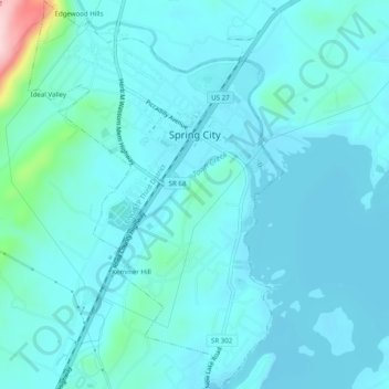
Name: Spring City topographic map, elevation, terrain.
Location: Spring City, Rhea County, Tennessee, United States (35.66568 -84.88197 35.70582 -84.84952)
Average elevation: 252 m
Minimum elevation: 223 m
Maximum elevation: 484 m
Make a donation
Gear up for your next adventure:
As an Amazon Associate, this site earns from qualifying purchases at no extra cost to you.
Other topographic maps
Click on a map to view its topography, its elevation and its terrain.
Make a donation
Gear up for your next adventure:
As an Amazon Associate, this site earns from qualifying purchases at no extra cost to you.
Mountain View
United States > Tennessee > Rhea County > Dayton > Mountain View
Average elevation: 276 m