
Great Gable topographic map
Interactive map
Click on the map to display elevation.
About this map
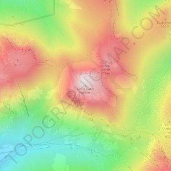
Name: Great Gable topographic map, elevation, terrain.
Average elevation: 509 m
Minimum elevation: 111 m
Maximum elevation: 893 m
Other topographic maps
Click on a map to view its topography, its elevation and its terrain.
Lincomb Tarns
United Kingdom > England > Cumberland > Borrowdale
Lincomb Tarns, Borrowdale, Cumberland, England, CA12 5XJ, United Kingdom
Average elevation: 556 m
Watendlath
United Kingdom > England > Cumberland > Borrowdale
Watendlath, Borrowdale, Cumberland, England, CA12 5UW, United Kingdom
Average elevation: 352 m