Geolocate

Alabel topographic map

Click on the map to display elevation.

About this map

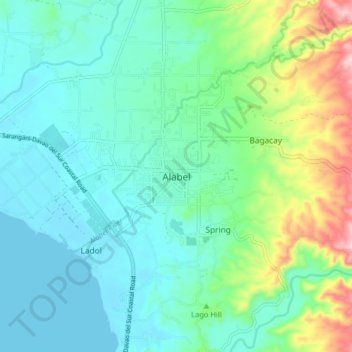
Name: Alabel topographic map, elevation, terrain.

Location: Alabel, Sarangani, Soccsksargen, 9501, Philippines (6.06278 125.25203 6.14278 125.33203)

Average elevation: 63 m

Minimum elevation: 0 m

Maximum elevation: 273 m

Other topographic maps

Click on a map to view its topography, its elevation and its terrain.

Sarangani Bay

Philippines > Sarangani

Average elevation: 103 m

Mainit River

Philippines > Sarangani

Average elevation: 279 m

Malungon

Philippines > Sarangani

Average elevation: 464 m

Glan River

Philippines > Sarangani

Average elevation: 384 m

Buayan River

Philippines > Sarangani > Malungon

Average elevation: 149 m

Gumasa Beach

Philippines > Sarangani > Glan

Average elevation: 60 m

Malungon

Philippines > Sarangani

Average elevation: 464 m

Gear up for your next adventure:

🪓Outdoor Multitools - Versatile tools for hiking and camping
🌂Windproof Trekking Umbrellas - Surprising but effective rain protection on low-wind trails
🧥Waterproof Hiking Jackets - Rain protection for walking in all weather conditions
🥾Women's Waterproof Hiking Boots - High-performance trekking boots designed for all-weather comfort
🛌Sleeping Bags - Warm and packable sleeping bags for outdoor nights

As an Amazon Associate, this site earns from qualifying purchases at no extra cost to you.