
Thank you for supporting this site ❤️
Make a donation
Make a donation
Gear up for your next adventure:
As an Amazon Associate, this site earns from qualifying purchases at no extra cost to you.
Miltenberg topographic map
Click on the map to display elevation.
Thank you for supporting this site ❤️
Make a donation
Make a donation
Gear up for your next adventure:
As an Amazon Associate, this site earns from qualifying purchases at no extra cost to you.
About this map
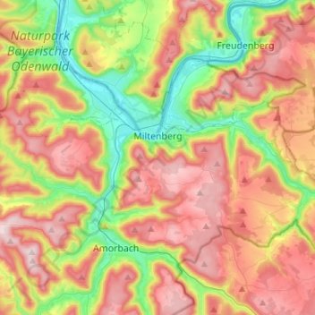
Name: Miltenberg topographic map, elevation, terrain.
Location: Miltenberg, Landkreis Miltenberg, Bavaria, 63897, Germany (49.65392 9.12120 49.72686 9.37267)
Average elevation: 310 m
Minimum elevation: 119 m
Maximum elevation: 513 m
Thank you for supporting this site ❤️
Make a donation
Make a donation
Gear up for your next adventure:
As an Amazon Associate, this site earns from qualifying purchases at no extra cost to you.
Other topographic maps
Click on a map to view its topography, its elevation and its terrain.
Miltenberg
Germany > Bavaria > Landkreis Miltenberg > Miltenberg > Miltenberg
Average elevation: 279 m