
Make a donation
Gear up for your next adventure:
As an Amazon Associate, this site earns from qualifying purchases at no extra cost to you.
Hengli topographic map
Click on the map to display elevation.
Make a donation
Gear up for your next adventure:
As an Amazon Associate, this site earns from qualifying purchases at no extra cost to you.
Hengli
Hengli Town is located on the banks of Huanbao and Yinhe Rivers. The Congguanshen Expressway crosses the eastern part of the town. It has an average elevation of 8 meters above the sea level.
Make a donation
Gear up for your next adventure:
As an Amazon Associate, this site earns from qualifying purchases at no extra cost to you.
About this map
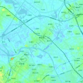
Name: Hengli topographic map, elevation, terrain.
Location: Hengli, Dongguan, Guangdong Province, China (22.98936 113.92171 23.06000 114.02715)
Average elevation: 8 m
Minimum elevation: -15 m
Maximum elevation: 61 m
Make a donation
Gear up for your next adventure:
As an Amazon Associate, this site earns from qualifying purchases at no extra cost to you.
Other topographic maps
Click on a map to view its topography, its elevation and its terrain.