
Stefaniada topographic map
Interactive map
Click on the map to display elevation.
About this map
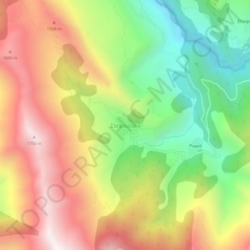
Name: Stefaniada topographic map, elevation, terrain.
Average elevation: 1,173 m
Minimum elevation: 565 m
Maximum elevation: 1,811 m
Other topographic maps
Click on a map to view its topography, its elevation and its terrain.
Neraida
Greece > Thessaly and Central Greece > Karditsa Regional Unit > Neraida
Neraida, Karditsa Municipality, Karditsa Regional Unit, Thessaly, Thessaly and Central Greece, 43100, Greece
Average elevation: 914 m
Δήμος Καρδίτσας
Greece > Thessaly and Central Greece > Karditsa Regional Unit
Δήμος Καρδίτσας, Karditsa Regional Unit, Thessaly, Thessaly and Central Greece, 43100, Greece
Average elevation: 473 m