
Make a donation
Gear up for your next adventure:
As an Amazon Associate, this site earns from qualifying purchases at no extra cost to you.
Trimley St Martin topographic map
Click on the map to display elevation.
Make a donation
Gear up for your next adventure:
As an Amazon Associate, this site earns from qualifying purchases at no extra cost to you.
Trimley St Martin
In 1741 the Suffolk Traveller John Kirby (topographer) surveyed the area around Felixstowe and in his note on Trimley he mentioned 'the lane to the pouch', which led to a small meadow east of the two churches, which contained a spring of clear water, generally regarded the source of Kingsfleet. The stream and can still be seen following out from a concrete opening which was constructed when the Civil Engineers covered the greater part of the meadow with what is now known as the Trimley Roundabout (A14 Junction 59). During dredging of the stream to assist the construction of the by-pass a mill-stone was discovered which was identified as being medieval. The path which runs between a smock mill, which was near Mill Lane, and the top of pouch meadow is called CrowsWell Way
Make a donation
Gear up for your next adventure:
As an Amazon Associate, this site earns from qualifying purchases at no extra cost to you.
About this map
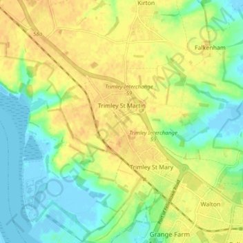
Name: Trimley St Martin topographic map, elevation, terrain.
Average elevation: 15 m
Minimum elevation: -6 m
Maximum elevation: 28 m
Suffolk trails, hiking, mountain biking, running and outdoor activities
Make a donation
Gear up for your next adventure:
As an Amazon Associate, this site earns from qualifying purchases at no extra cost to you.
Other topographic maps
Click on a map to view its topography, its elevation and its terrain.
Gunton Sands
United Kingdom > England > Suffolk > East Suffolk > Lowestoft > Corton
Average elevation: 10 m
Make a donation
Gear up for your next adventure:
As an Amazon Associate, this site earns from qualifying purchases at no extra cost to you.
Sutton Hoo Archeological Site
United Kingdom > England > Suffolk > East Suffolk > Sutton
Average elevation: 19 m
Make a donation
Gear up for your next adventure:
As an Amazon Associate, this site earns from qualifying purchases at no extra cost to you.
Lowestoft Inner Harbour
United Kingdom > England > Suffolk > East Suffolk > Lowestoft > Oulton Broad
Average elevation: 8 m
Site of old Orfordness Lighthouse
United Kingdom > England > Suffolk > East Suffolk > Orford
Average elevation: 0 m
Rendlesham UFO Landing Site #2
United Kingdom > England > Suffolk > East Suffolk > Butley Abbey
Average elevation: 14 m
Make a donation
Gear up for your next adventure:
As an Amazon Associate, this site earns from qualifying purchases at no extra cost to you.
Make a donation
Gear up for your next adventure:
As an Amazon Associate, this site earns from qualifying purchases at no extra cost to you.
Make a donation
Gear up for your next adventure:
As an Amazon Associate, this site earns from qualifying purchases at no extra cost to you.
Make a donation
Gear up for your next adventure:
As an Amazon Associate, this site earns from qualifying purchases at no extra cost to you.
Eygpt Wood
United Kingdom > England > Suffolk > East Suffolk > Trimley St Martin
Average elevation: 16 m
Eygpt Wood
United Kingdom > England > Suffolk > East Suffolk > Trimley St Martin
Average elevation: 16 m