
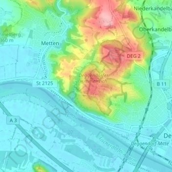
Schalterbach topographic map
Interactive map
Click on the map to display elevation.
About this map
Name: Schalterbach topographic map, elevation, terrain.
Average elevation: 338 m
Minimum elevation: 310 m
Maximum elevation: 428 m
Other topographic maps
Click on a map to view its topography, its elevation and its terrain.
Großwalding
Deutschland > Bayern > Landkreis Deggendorf > Deggendorf > Kleinfilling
Großwalding, Kleinfilling, Deggendorf, Landkreis Deggendorf, Bayern, 94469, Deutschland
Average elevation: 420 m
Mietzing
Deutschland > Bayern > Landkreis Deggendorf > Deggendorf
Mietzing, Deggendorf, Landkreis Deggendorf, Bayern, 94469, Deutschland
Average elevation: 437 m
Scheidham
Deutschland > Bayern > Landkreis Deggendorf > Deggendorf > Reinprechting
Scheidham, Reinprechting, Deggendorf, Landkreis Deggendorf, Bayern, 94469, Deutschland
Average elevation: 415 m
Reinprechting
Deutschland > Bayern > Landkreis Deggendorf > Deggendorf
Reinprechting, Deggendorf, Landkreis Deggendorf, Bayern, 94469, Deutschland
Average elevation: 396 m