
Make a donation
Gear up for your next adventure:
As an Amazon Associate, this site earns from qualifying purchases at no extra cost to you.
Chao topographic map
Click on the map to display elevation.
Make a donation
Gear up for your next adventure:
As an Amazon Associate, this site earns from qualifying purchases at no extra cost to you.
About this map
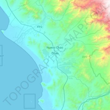
Name: Chao topographic map, elevation, terrain.
Location: Chao, Province of Virú, La Libertad, Peru (-8.77502 -78.75562 -8.32126 -78.23558)
Average elevation: 428 m
Minimum elevation: -2 m
Maximum elevation: 3,845 m
Make a donation
Gear up for your next adventure:
As an Amazon Associate, this site earns from qualifying purchases at no extra cost to you.
Other topographic maps
Click on a map to view its topography, its elevation and its terrain.
Trujillo
Trujillo is located at an altitude of 34 metres (112 feet) on a coastal strip in the west of the province of Trujillo, in the old valley of Chimor today known as the Moche or Santa Catalina Valley. Its main square is located at 8°6′3″S 79°1′34″W / 8.10083°S 79.02611°W / -8.10083; -79.02611…
Average elevation: 213 m
Make a donation
Gear up for your next adventure:
As an Amazon Associate, this site earns from qualifying purchases at no extra cost to you.
Make a donation
Gear up for your next adventure:
As an Amazon Associate, this site earns from qualifying purchases at no extra cost to you.