Geolocate

Devgarh topographic map

Click on the map to display elevation.

About this map

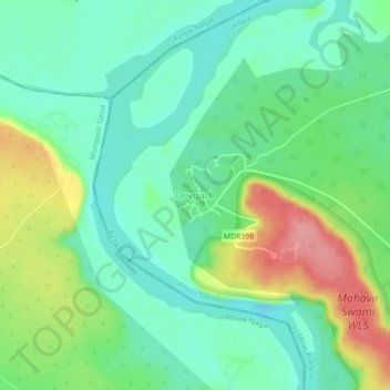
Name: Devgarh topographic map, elevation, terrain.

Location: Devgarh, Lalitpur Tehsil, Lalitpur, Uttar Pradesh, India (24.50413 78.21575 24.54413 78.25575)

Average elevation: 384 m

Minimum elevation: 348 m

Maximum elevation: 455 m

Gear up for your next adventure:

📱Rugged Phone Cases - Heavy-duty protection for smartphones used as secondary GPS tools
🛌Sleeping Bags - Warm and packable sleeping bags for outdoor nights
🧭Emergency Beacons - Safety beacons for remote outdoor locations
🛰️Handheld GPS Devices - Reliable GPS units for hiking and outdoor navigation
🥾Hiking Boots - Waterproof and durable boots for long-distance hiking in the UK

As an Amazon Associate, this site earns from qualifying purchases at no extra cost to you.