
Uplands topographic map
Interactive map
Click on the map to display elevation.
About this map
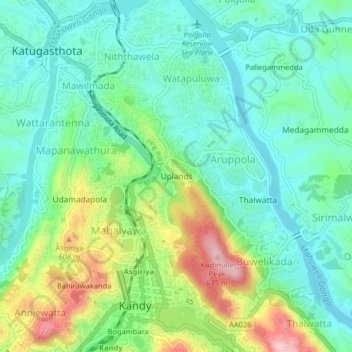
Name: Uplands topographic map, elevation, terrain.
Average elevation: 492 m
Minimum elevation: 429 m
Maximum elevation: 636 m
Other topographic maps
Click on a map to view its topography, its elevation and its terrain.
Kandy
Sri Lanka > Central Province > Kandy
Kandy, Kandy District, Central Province, 20000, Sri Lanka
Average elevation: 621 m
Hantana
Sri Lanka > Central Province > Kandy > Hantana
Hantana, Kandy, Kandy District, Central Province, 85129, Sri Lanka
Average elevation: 706 m
Bogambara
Sri Lanka > Central Province > Kandy > Bogambara
Bogambara, Kandy, Kandy District, Central Province, 20000, Sri Lanka
Average elevation: 560 m