Geolocate

Salug topographic map

Click on the map to display elevation.

About this map

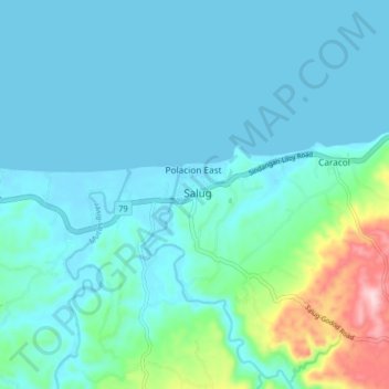
Name: Salug topographic map, elevation, terrain.

Location: Salug, Zamboanga del Norte, Zamboanga Peninsula, Philippines (8.06742 122.71769 8.14742 122.79769)

Average elevation: 42 m

Minimum elevation: -2 m

Maximum elevation: 279 m

Other topographic maps

Click on a map to view its topography, its elevation and its terrain.

Gear up for your next adventure:

🧴Tick Removal Tools - Small, essential health tool for UK woodland and moorland
👟Heavy Duty Boot Laces - Always carry a spare for your hiking footwear
👖Convertible Hiking Trousers - Versatile zip-off pants for changing mountain weather conditions
👕Merino Base Layers - Natural temperature regulation for cold weather hiking and camping
🥼Base Layers - Thermal base layers for temperature regulation

As an Amazon Associate, this site earns from qualifying purchases at no extra cost to you.