
Henniker topographic map
Interactive map
Click on the map to display elevation.
Henniker
Craney Hill, elevation 1,402 feet (427 m) above sea level and home of the Pats Peak ski area, is in the south. The highest point in Henniker is an unnamed summit near the town's northwest corner, with an elevation of 1,552 ft (473 m).
About this map
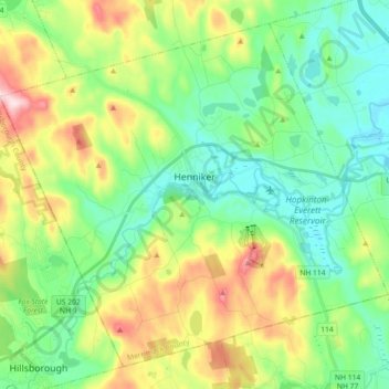
Name: Henniker topographic map, elevation, terrain.
Average elevation: 223 m
Minimum elevation: 109 m
Maximum elevation: 469 m
Other topographic maps
Click on a map to view its topography, its elevation and its terrain.
Rings Corner
United States > New Hampshire > Merrimack County > Pittsfield > Rings Corner
Average elevation: 190 m