
Lagunas topographic map
Interactive map
Click on the map to display elevation.
About this map
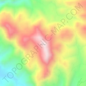
Name: Lagunas topographic map, elevation, terrain.
Average elevation: 3,227 m
Minimum elevation: 2,936 m
Maximum elevation: 3,478 m
Other topographic maps
Click on a map to view its topography, its elevation and its terrain.
Volcán Parinacota
Chile > Región de Arica y Parinacota > Putre
Volcán Parinacota, Putre, Provincia de Parinacota, Región de Arica y Parinacota, Chile
Average elevation: 5,808 m
Río Lauca
Chile > Región de Arica y Parinacota > Putre
Río Lauca, Putre, Provincia de Parinacota, Región de Arica y Parinacota, Chile
Average elevation: 4,165 m