Geolocate

Cloghatacka topographic map

Click on the map to display elevation.

About this map

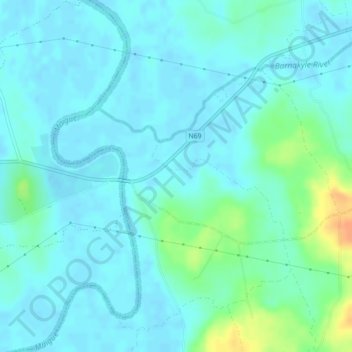
Name: Cloghatacka topographic map, elevation, terrain.

Location: Cloghatacka, Clarina, The Metropolitan District of Limerick City, Limerick, County Limerick, Munster, Ireland (52.61485 -8.77347 52.62517 -8.74487)

Average elevation: 7 m

Minimum elevation: -1 m

Maximum elevation: 36 m

Other topographic maps

Click on a map to view its topography, its elevation and its terrain.

Ballybrown

Ireland > County Limerick > Limerick

Average elevation: 9 m

Mungret

Ireland > County Limerick > Limerick

Average elevation: 10 m

Ahane

Ireland > County Limerick > Limerick

Average elevation: 31 m

Mungret

Ireland > County Limerick > Limerick

Average elevation: 10 m

Rich Hill

Ireland > County Limerick > Limerick > Ahane

Average elevation: 31 m

Limerick

Ireland > County Limerick > Limerick

Limerick's climate is classified as temperate oceanic (Köppen Cfb). Met Éireann maintains a climatological weather station at Shannon Airport, 20 kilometres west of the city in County Clare. Shannon Airport records an average of 977 millimetres of precipitation annually, most of which is rain. Limerick has a…

Average elevation: 10 m

Gear up for your next adventure:

🎒Replacement Sternum Straps - Repair parts for hiking rucksacks
🧘Folding Sit Mats - Dry and warm seat for map-reading breaks on damp ground
📕Outdoor Navigation Books - Learn traditional and modern navigation techniques
👕Merino Base Layers - Natural temperature regulation for cold weather hiking and camping
🎒Multi-day Trekking Packs - Large capacity backpacks for wild camping and long-distance trails

As an Amazon Associate, this site earns from qualifying purchases at no extra cost to you.