
Roys Peak topographic map
Interactive map
Click on the map to display elevation.
About this map
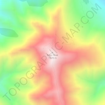
Name: Roys Peak topographic map, elevation, terrain.
Location: Roys Peak, Queenstown-Lakes District, Otago, New Zealand (-44.69405 169.04868 -44.69395 169.04878)
Average elevation: 1,099 m
Minimum elevation: 591 m
Maximum elevation: 1,577 m
Other topographic maps
Click on a map to view its topography, its elevation and its terrain.
Queenstown
New Zealand > Otago > Queenstown-Lakes District
Queenstown, Queenstown-Lakes District, Otago, 9348, New Zealand
Average elevation: 592 m
Mount Head
New Zealand > Otago > Queenstown-Lakes District
Mount Head, Queenstown-Lakes District, Otago, New Zealand
Average elevation: 1,992 m
Queenstown Hill
New Zealand > Otago > Queenstown-Lakes District > Queenstown
Queenstown Hill, Queenstown, Queenstown-Lakes District, Otago, 9300, New Zealand
Average elevation: 700 m
Prince of Wales
New Zealand > Otago > Queenstown-Lakes District
Prince of Wales, Queenstown-Lakes District, Otago, New Zealand
Average elevation: 1,274 m
Coronet Peak
New Zealand > Otago > Queenstown-Lakes District
Coronet Peak, Queenstown-Lakes District, Otago, New Zealand
Average elevation: 1,304 m
Cardrona
New Zealand > Otago > Queenstown-Lakes District
Cardrona, Queenstown-Lakes District, Otago, New Zealand
Average elevation: 758 m
Wānaka
New Zealand > Otago > Queenstown-Lakes District
Wānaka, Queenstown-Lakes District, Otago, 9305, New Zealand
Average elevation: 381 m
Glendhu Bay
New Zealand > Otago > Queenstown-Lakes District
Glendhu Bay, Queenstown-Lakes District, Otago, New Zealand
Average elevation: 406 m