
Fonthill topographic map
Click on the map to display elevation.
About this map
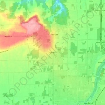
Name: Fonthill topographic map, elevation, terrain.
Average elevation: 193 m
Minimum elevation: 146 m
Maximum elevation: 260 m
Other topographic maps
Click on a map to view its topography, its elevation and its terrain.
Pelham
Canada > Ontario > Niagara Region > Pelham
From the top of the Fonthill Kame Delta hill, a unique topographical feature (Ontario Geological Society 1970) and ANSI protected site (Area of Natural Scientific Interest - ANSI) on a clear day it is possible to see Toronto, Hamilton and western New York state. At one time, a ski tow was installed on the…
Average elevation: 183 m
Niagara River
Canada > Ontario > Niagara Region > Niagara Falls
The river, which is occasionally described as a strait, is about 58 kilometres (36 mi) long and includes Niagara Falls in its course. The falls have moved approximately 11 kilometres (6.8 mi) upstream from the Niagara Escarpment in the last 12,000 years, resulting in a gorge below the falls. Today, the…
Average elevation: 177 m