
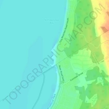
Allenwood Beach topographic map
Interactive map
Click on the map to display elevation.
About this map
Name: Allenwood Beach topographic map, elevation, terrain.
Average elevation: 183 m
Minimum elevation: 172 m
Maximum elevation: 213 m
Other topographic maps
Click on a map to view its topography, its elevation and its terrain.
Perkinsfield
Canada > Ontario > Simcoe County > Tiny
Perkinsfield, Tiny, Simcoe County, Central Ontario, Ontario, L0L 2J0, Canada
Average elevation: 232 m
Wyebridge
Canada > Ontario > Simcoe County > Tiny
Wyebridge, Tiny, Simcoe County, Central Ontario, Ontario, L4R 0G1, Canada
Average elevation: 209 m
Bluewater Beach
Canada > Ontario > Simcoe County > Tiny
Bluewater Beach, Tiny, Simcoe County, Central Ontario, Ontario, Canada
Average elevation: 183 m
Lafontaine
Canada > Ontario > Simcoe County > Tiny
Lafontaine, Tiny, Simcoe County, Central Ontario, Ontario, L9T 0H1, Canada
Average elevation: 218 m