
Kelmarsh topographic map
Click on the map to display elevation.
About this map
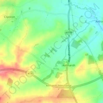
Name: Kelmarsh topographic map, elevation, terrain.
Location: Kelmarsh, West Northamptonshire, England, United Kingdom (52.39473 -0.95652 52.43395 -0.88817)
Average elevation: 138 m
Minimum elevation: 106 m
Maximum elevation: 190 m
West Northamptonshire trails, hiking, mountain biking, running and outdoor activities
Other topographic maps
Click on a map to view its topography, its elevation and its terrain.
Lower Thorpe
United Kingdom > England > West Northamptonshire > Thorpe Mandeville
Average elevation: 154 m
Ravensthorpe Reservoir
United Kingdom > England > West Northamptonshire > Coton
Average elevation: 131 m