
Make a donation
Gear up for your next adventure:
As an Amazon Associate, this site earns from qualifying purchases at no extra cost to you.
Toén topographic map
Click on the map to display elevation.
Make a donation
Gear up for your next adventure:
As an Amazon Associate, this site earns from qualifying purchases at no extra cost to you.
Toén
Las zonas de mayor altitud se sitúan en la franja sur y en la franja este, pero aun así no existen cimas muy elevadas, puesto que casi no se superan los 600 metros. Las tierras del norte, oeste y centro del municipio forman el extenso valle del Río Miño. Este río está embalsado en el embalse de Castrelo de Miño y los demás ríos, el Regato de Puga, el Rego de Xestosa , el Rego de Fragoso , el Rego do Anguieiro (Feá)y el regato do Valvon ( Feá) , el regato de Quenlle, el regato de Freixendo vierten sus aguas en el río y en la cola del embalse.
Make a donation
Gear up for your next adventure:
As an Amazon Associate, this site earns from qualifying purchases at no extra cost to you.
About this map
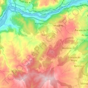
Name: Toén topographic map, elevation, terrain.
Location: Toén, Ourense, Galicia, 32930, España (42.26601 -8.02332 42.34473 -7.89391)
Average elevation: 348 m
Minimum elevation: 85 m
Maximum elevation: 625 m
Make a donation
Gear up for your next adventure:
As an Amazon Associate, this site earns from qualifying purchases at no extra cost to you.
Other topographic maps
Click on a map to view its topography, its elevation and its terrain.
Make a donation
Gear up for your next adventure:
As an Amazon Associate, this site earns from qualifying purchases at no extra cost to you.