
Underberg topographic map
Click on the map to display elevation.
About this map
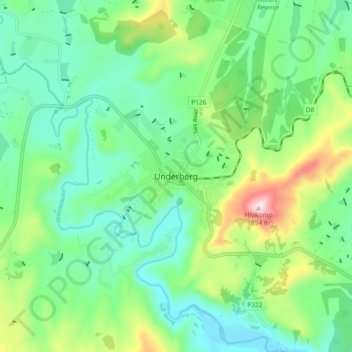
Name: Underberg topographic map, elevation, terrain.
Average elevation: 1,552 m
Minimum elevation: 1,415 m
Maximum elevation: 1,901 m
Other topographic maps
Click on a map to view its topography, its elevation and its terrain.
Umzimkulu
South Africa > KwaZulu-Natal > Sisonke District Municipality > Kwa Sani Local Municipality
Average elevation: 1,523 m
Umzimkulu
South Africa > KwaZulu-Natal > Sisonke District Municipality > Kwa Sani Local Municipality
Average elevation: 1,517 m
Goxhil Dam
South Africa > KwaZulu-Natal > Sisonke District Municipality > Kwa Sani Local Municipality
Average elevation: 1,509 m
Kwa Sani Local Municipality
South Africa > KwaZulu-Natal > Sisonke District Municipality > Kwa Sani Local Municipality
Average elevation: 1,905 m