Geolocate

Corona Ridge topographic map

Click on the map to display elevation.

About this map

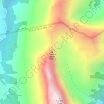
Name: Corona Ridge topographic map, elevation, terrain.

Location: Corona Ridge, Clearwater County, Alberta, Canada (51.94760 -116.57350 51.94770 -116.57340)

Average elevation: 2,386 m

Minimum elevation: 1,903 m

Maximum elevation: 3,066 m

Other topographic maps

Click on a map to view its topography, its elevation and its terrain.

Tay River

Canada > Alberta > Clearwater County

Average elevation: 1,204 m

Gear up for your next adventure:

🥄Titanium Camping Sporks - The ultimate lightweight utensil for trail meals
🎒Replacement Sternum Straps - Repair parts for hiking rucksacks
🧥Softshell Jackets - Breathable jackets for active outdoor use
🧊Personal Water Filters - Drink safely from mountain streams marked on your map
🥾Men's Waterproof Hiking Boots - Durable footwear with deep lugs for muddy and rocky UK terrains

As an Amazon Associate, this site earns from qualifying purchases at no extra cost to you.