Geolocate

Kumsu topographic map

Click on the map to display elevation.

About this map

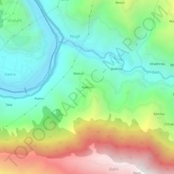
Name: Kumsu topographic map, elevation, terrain.

Location: Kumsu, Nogli, Rampur, Shimla District, Himachal Pradesh, India (31.36937 77.62182 31.40937 77.66182)

Average elevation: 1,412 m

Minimum elevation: 883 m

Maximum elevation: 2,385 m

Gear up for your next adventure:

👖Convertible Hiking Trousers - Versatile zip-off pants for changing mountain weather conditions
🧼Biodegradable Soap - Leave-no-trace hygiene for multi-day mountain treks
🗺️Scratch-off Peak Maps - Track your progress climbing Munros or Wainwrights
🧦Merino Wool Hiking Socks - Moisture-wicking socks to prevent blisters during long mountain walks
🔋Lithium AA Batteries - Long-lasting power that performs well in cold mountain weather

As an Amazon Associate, this site earns from qualifying purchases at no extra cost to you.