
Weston Hill topographic map
Interactive map
Click on the map to display elevation.
About this map
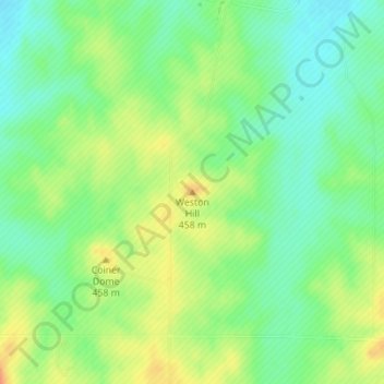
Name: Weston Hill topographic map, elevation, terrain.
Location: Weston Hill, Saline County, Kansas, United States (38.69246 -97.84954 38.69256 -97.84944)
Average elevation: 437 m
Minimum elevation: 418 m
Maximum elevation: 461 m
Other topographic maps
Click on a map to view its topography, its elevation and its terrain.
Kipp
United States > Kansas > Saline County
Kipp, Saline County, Kansas, United States
Average elevation: 374 m
New Cambria
United States > Kansas > Saline County
New Cambria, Saline County, Kansas, United States
Average elevation: 364 m
Salemsborg
United States > Kansas > Saline County
Salemsborg, Saline County, Kansas, United States
Average elevation: 399 m
Salina
United States > Kansas > Saline County
Salina, Saline County, Kansas, 67401, United States
Average elevation: 383 m
Gypsum
United States > Kansas > Saline County
Gypsum, Saline County, Kansas, United States
Average elevation: 378 m