
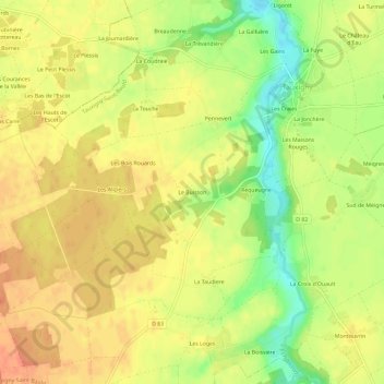
Le Buisson topographic map
Interactive map
Click on the map to display elevation.
About this map
Name: Le Buisson topographic map, elevation, terrain.
Average elevation: 97 m
Minimum elevation: 69 m
Maximum elevation: 113 m
Other topographic maps
Click on a map to view its topography, its elevation and its terrain.
Les Trizaies
France > Centre-Val de Loire > Indre-et-Loire > Tauxigny-Saint-Bauld
Les Trizaies, Tauxigny, Tauxigny-Saint-Bauld, Loches, Indre-et-Loire, Centre-Val de Loire, France métropolitaine, 37310, France
Average elevation: 100 m
Le Bois Joly
France > Centre-Val de Loire > Indre-et-Loire > Tauxigny-Saint-Bauld
Le Bois Joly, Tauxigny, Tauxigny-Saint-Bauld, Loches, Indre-et-Loire, Centre-Val de Loire, France métropolitaine, 37310, France
Average elevation: 83 m
Saint-Bauld
France > Centre-Val de Loire > Indre-et-Loire > Tauxigny-Saint-Bauld
Saint-Bauld, Tauxigny-Saint-Bauld, Loches, Indre-et-Loire, Centre-Val de Loire, France métropolitaine, 37310, France
Average elevation: 96 m
Tauxigny
France > Centre-Val de Loire > Indre-et-Loire > Tauxigny-Saint-Bauld
Tauxigny, Tauxigny-Saint-Bauld, Loches, Indre-et-Loire, Centre-Val de Loire, France métropolitaine, 37310, France
Average elevation: 94 m