
Make a donation
Gear up for your next adventure:
As an Amazon Associate, this site earns from qualifying purchases at no extra cost to you.
Kalpi topographic map
Click on the map to display elevation.
Make a donation
Gear up for your next adventure:
As an Amazon Associate, this site earns from qualifying purchases at no extra cost to you.
About this map
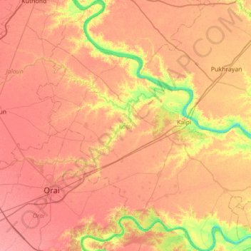
Name: Kalpi topographic map, elevation, terrain.
Location: Kalpi, Jalaun District, Uttar Pradesh, India (25.86445 79.42042 26.36261 79.95440)
Average elevation: 132 m
Minimum elevation: 93 m
Maximum elevation: 154 m
Make a donation
Gear up for your next adventure:
As an Amazon Associate, this site earns from qualifying purchases at no extra cost to you.
Other topographic maps
Click on a map to view its topography, its elevation and its terrain.
Make a donation
Gear up for your next adventure:
As an Amazon Associate, this site earns from qualifying purchases at no extra cost to you.
Make a donation
Gear up for your next adventure:
As an Amazon Associate, this site earns from qualifying purchases at no extra cost to you.
Raebareli
India > Uttar Pradesh > Raebareli
The district forms a part of the Gangetic plain which is of recent origin according to geological chronology and reveal ordinary Gangetic alluvium. The district being a part of the alluvial plain conforms to the same geological sequence as the plain itself. The only mineral of importance is kankar. The…
Average elevation: 111 m
Make a donation
Gear up for your next adventure:
As an Amazon Associate, this site earns from qualifying purchases at no extra cost to you.
Govardhan
India > Uttar Pradesh > Mathura
Govardhana is located at 27°30′N 77°28′E / 27.5°N 77.47°E / 27.5; 77.47. It has an average elevation of 179 metres (587 feet). Govardhana has been made Tehsil in Mathura District by the Uttar Pradesh government.
Average elevation: 181 m
Make a donation
Gear up for your next adventure:
As an Amazon Associate, this site earns from qualifying purchases at no extra cost to you.
Mirzapur
India > Uttar Pradesh > Mirzapur
Mirzapur is located at 25°09′N 82°35′E / 25.15°N 82.58°E / 25.15; 82.58. It has an average elevation of 80 metres (265 feet). The District of Mirzapur lies between the parallels of 23.52 & 25.32 North latitude and 82.7 and 83.33 East longitude. It forms a portion of the Varanasi district. On…
Average elevation: 83 m
Make a donation
Gear up for your next adventure:
As an Amazon Associate, this site earns from qualifying purchases at no extra cost to you.
Sahaspur
India > Uttar Pradesh > Dhampur
Sahaspur is located at 29°07′16″N 78°37′16″E / 29.121°N 78.621°E / 29.121; 78.621. It has an average elevation of 199 metres (653 feet).
Average elevation: 217 m
Make a donation
Gear up for your next adventure:
As an Amazon Associate, this site earns from qualifying purchases at no extra cost to you.